Archive for the ‘Cycling’ Category


Projekte

Markings Are Effective: Overtaking Distances Increased

The city of Salzburg has published the results of its real-world laboratory on Nußdorferstraße: the tested road markings measurably increase the distance at which motor vehicles overtake cyclists. In particular, wide, multi-purpose lanes improve road safety.

More distance thanks to clear markings

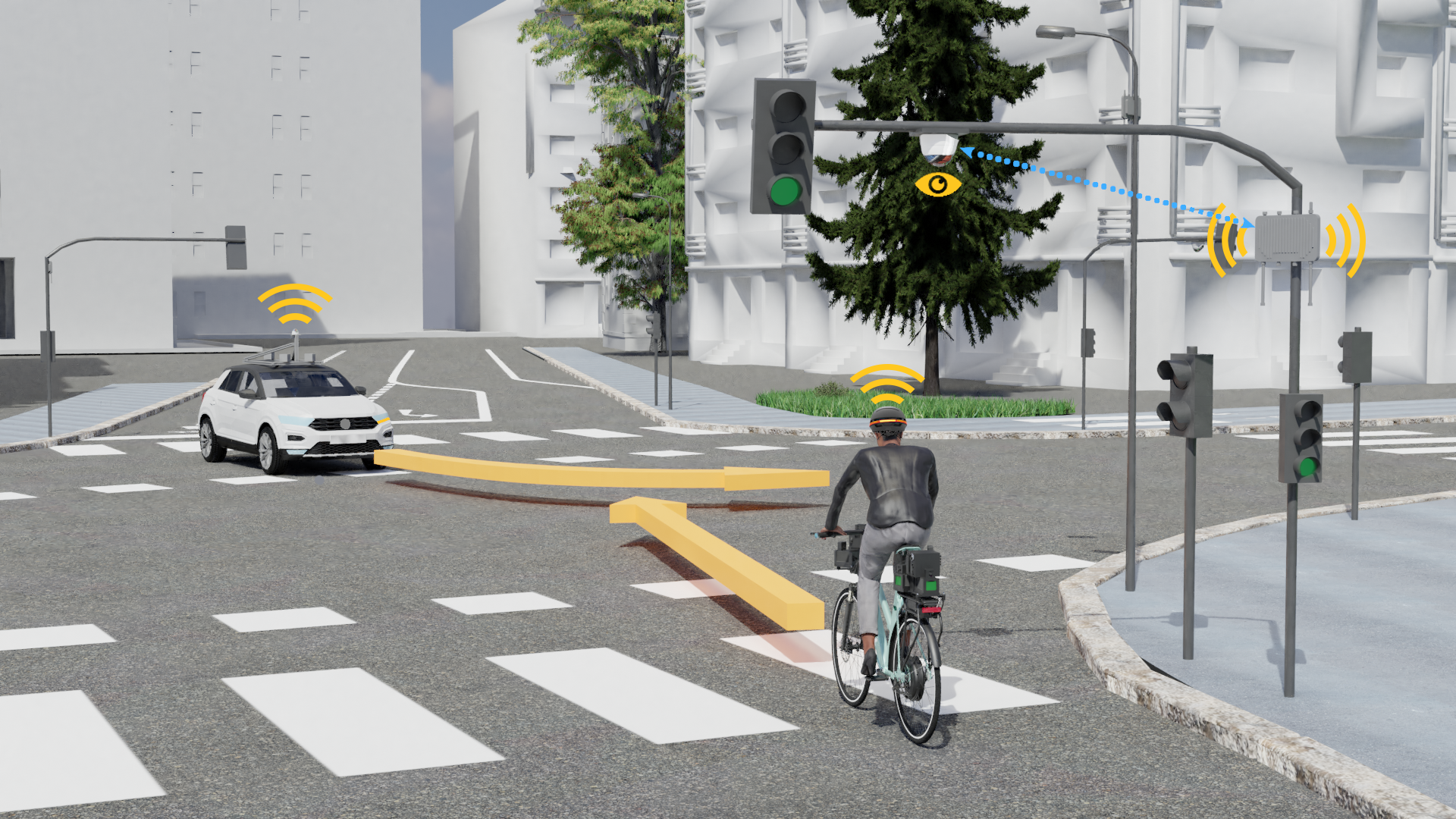
In the second half of 2025, two types of road marking were trialled in the real-world laboratory on Nußdorferstraße to improve safety for cyclists. Test riders on the research bicycle by Salzburg Research have proven effective: drivers are keeping a greater distance when overtaking and many cyclists report feeling safer.

Two sections with different markings were examined:

  • Wide multi-purpose lanes two meters wide and narrow central lanes three meters wide.
  • Large bicycle pictograms with so-called sharrows.

The measurement trips took place in two phases: one in June and one in September and October 2025. Following feedback from the first phase, additional signs were installed to indicate the correct way to overtake.

356 overtaking maneuvers analyzed scientifically

A total of 356 overtaking maneuvers were recorded and evaluated. In the second phase, the median overtaking distance was as follows:

  • 1.12 meters in the section with wide multi-purpose lanes and a narrow central roadway
  • 1.05 meters in the section with large wheel pictograms and sharrows

This increased the distance in both variants. However, when overtaking at speeds of over 30 km/h, the legally prescribed minimum distance of 1.5 meters is still not achieved.

The analysis also shows that oncoming traffic affects overtaking behavior. On a positive note, some drivers can be seen to delay overtaking until it is safe to do so. Additionally, the introduction of the 30 km/h speed limit in the real-world laboratory contributes to improving road safety.

Wide multi-purpose strips particularly effective

These findings are also confirmed by feedback from the public. A total of 442 people took part in the consultation. Sixty percent of cyclists said they felt safer on wide multi-purpose lanes, while 53 percent said they felt safer with large bicycle pictograms and sharrows.

Scientific analysis shows that clear markings increase awareness and can contribute to greater overtaking distances. Based on this, the city of Salzburg plans to identify suitable locations within the urban area where these measures can be implemented in cases where structural solutions are not possible.

Both options are sensible, but the wide multi-purpose lanes are more effective. It is therefore recommended that these lanes be implemented throughout Nußdorferstraße in the future and that other suitable locations in the city be examined.

The real-world laboratory was set up by zukunftswege.at the mobility laboratory in collaboration with Salzburg Research Forschungsgesellschaft and Con. Sens Mobilitätsdesign, acting on behalf of the City and State of Salzburg.

More information:

Safe Cycling on Rural Roads: Testing New Road Markings

How can cycling on rural roads be made safer? A new research project led by Salzburg Research is investigating this question. Funded by the Federal Ministry of Innovation, Mobility, and Infrastructure, the project is examining whether multi-purpose lanes with a narrow central lane could provide a solution to increase safety for cyclists on rural roads and address gaps in the cycle path network.

Pilot trials in three federal states

Initial pilot studies are currently underway in Burgenland, Carinthia, and Vorarlberg. These studies are accompanied by state-of-the-art sensor technology and social science surveys. The aim is to establish a solid scientific foundation for future transport planning, which is an important step towards safer and more climate-friendly mobility.

“We need new approaches to close gaps in the cycle path network outside cities where local conditions do not permit structurally separate cycle paths. Multi-purpose lanes with a narrow central carriageway are a promising model that we are now scientifically testing,” explains Sven Leitinger, project manager of the MZSFreiland research project and a researcher at Salzburg Research.

What are multi-purpose strips?

Multi-purpose lanes are specially marked sections of the road intended primarily for bicycle traffic but which may also be used by other vehicles under certain conditions. In Austria, the use of multi-purpose lanes with a narrow core carriageway (< 4.5 metres) is currently only permitted up to a maximum speed of 30 km/h in urban areas and is currently not possible on rural roads. For the first time, the MZSFreiland project is investigating the possibilities for their use on rural roads and examining their safety effects, acceptance, and practical feasibility.

Sensory analysis and social research in action

Salzburg Research uses state-of-the-art measurement methods to collect objective data: the Holoscene Research Bicycle uses LiDAR and video sensors to accurately record overtaking maneuvers involving motor vehicles and cyclists. Open Bike sensors and side radars also measure traffic volumes, speeds, and vehicle types.

Boreal Holoscene Bike 2025

At the same time, social science surveys and test rides are being conducted. “Our interest lies not only in objective safety but also in how safe cyclists feel and how acceptable the measure is to the general public,” emphasizes Eva Aigner-Breuss from the Austrian Road Safety Board (KFV).

Three test routes in Burgenland, Carinthia, and Vorarlberg

  • Burgenland: A 1.1 km gap in the cycle network on the P456 Weppersdorfer Straße, between Weppersdorf and Lackenback, is being closed.
  • Carinthia: A section of approximately 1 km of the L96 Wörthersee Südufer Straße between Auen and Oberdellach has been adapted for bicycle traffic.
  • Vorarlberg: An uphill section of the L50 Montfortstraße, between Götzis and St. Arbogast, is under investigation.

The test routes will be marked in autumn 2025. Following an adjustment period, measurements and surveys will be conducted until the summer of 2026, with the results to be published in autumn 2026.


Research for safe, climate-friendly mobility

The MZSFreiland project is funded by the Climate and Energy Fund as part of the Zero Emission Mobility Plus 2024 program. It brings together experts from technology, transport planning, and social research:

  • Salzburg Research: Project coordination, sensor technology, and data analysis
  • con.sens verkehrsplanung: Bicycle traffic planning and policy development
  • Kuratorium für Verkehrssicherheit (KFV): Safety analyses and acceptance research

The provincial governments of Burgenland, Carinthia, and Vorarlberg, along with local mobility agencies, are also involved.

“Our goal is to provide transportation planners with an evidence-based foundation for implementing special solutions. These initiatives will make it possible to build bicycle facilities in areas where this was previously impossible,” says Michael Szeiler of con.sens verkehrsplanung.

Research Bike Tests the Effectiveness of New Road Markings

Salzburg is testing new road markings to improve safety for cyclists. Salzburg Research is using a special research bicycle to study the effect of the new road markings on the distance between overtaking motor vehicles and cyclists. Until now, the average overtaking distance was only 85 centimeters, which is well below the legally required minimum of 1.5 meters.

The city of Salzburg is taking an innovative step to improve safety for cyclists: since mid-May, a traffic trial has been underway on Nußdorferstraße to test new road markings. The goal is to improve visibility and protection for cyclists with wider multi-purpose lanes and eye-catching bicycle pictograms, as well as scientific support from the Salzburg Research Institute.

New markings, clearer message

The urban mobility laboratory zukunftswege.at has implemented two different types of markings on behalf of the city and state of Salzburg:

  • Between Bräuhausstraße and Moosstraße, two-meter-wide multipurpose lanes with bicycle pictograms have been installed. The center of the road remains reserved for general traffic, with a width of three meters.
  • On the section from Moosstraße to Leopoldskronstraße, the effect of large-scale sharrows (pictograms with directional arrows) on safety is being tested. These were applied at regular intervals of around 25 meters.

The new markings are an inexpensive way to signal to all road users that cyclists need more space.

High-tech bicycle collects objective safety data

Salzburg Research uses a state-of-the-art research bicycle to evaluate the effectiveness of the markings. Equipped with LiDAR sensors and other measuring instruments, the bicycle records every overtaking situation in three dimensions with centimeter precision, from the car’s approach to the return to the lane.

Even before the new markings were introduced, the section was tested using the research bike. The results showed that in half of all overtaking maneuvers, the distance was only 85 centimeters or less—significantly less than the legal minimum of 1.5 meters.

The sensor technology generates so-called point clouds, in which the vehicles can be precisely located and the distance to the bicycle can be accurately measured. This data is incorporated into the scientific evaluation of the measures and provides a reliable basis for decisions regarding traffic planning.

Erfassung von Überholvorgängen mit der LiDAR-Sensorik am Forschungsfahrrad: Die Punktewolke zeigt einen Überholvorgang bei Gegenverkehr mit einem Überholabstand von etwa einem Meter. © Salzburg Research
Recording overtaking maneuvers with LiDAR sensor technology on the research bicycle: The point cloud shows an overtaking maneuver in oncoming traffic with an overtaking distance of approximately one meter © Salzburg Research

Next test phase starts in August

In August, the trial will be expanded to include red block markings added to the existing markings. After a familiarization period, the research bicycle will be used to test and analyze this variant. Additionally, citizens can share their subjective experiences and impressions in an online survey. These assessments will be included in the overall evaluation alongside the measurement data.

Science as a guide to better cycling infrastructure

The results of the traffic trial are expected in November 2025. The results will provide a scientifically sound basis for decision-making by the planning departments of the city of Salzburg on how narrow streets can be made more bicycle-friendly in the future. In this way, Salzburg is consistently pursuing its goal of promoting active mobility while at the same time increasing safety for all road users.


More information:

Making Cycling Safer in Constricted Road Conditions

How close and how dangerous are overtaking maneuvers between motor vehicles and cyclists, actually? Under the leadership of Salzburg Research, researchers from Germany, Austria, and Switzerland investigated over 7,000 overtaking maneuvers using state-of-the-art measurement technologies. The results were used to develop concrete recommendations for the safe and comfortable management of cycling traffic.

Road cross sections are often not wide enough to accommodate structurally separated bicycle facilities that meet the guidelines. In the absence of suitable alternative routes, these road sections usually remain gaps in the cycling network. Conflicts that affect road safety accumulate on these sections, in both urban and rural areas.

In a transnational research project led by Salzburg Research, empirical studies and state-of-the-art measurement technologies were used to develop concrete recommendations on how to make cycling on main roads safer and more comfortable under constricted conditions. Using Open Bike Sensors, stationary and mobile laser systems (LiDAR — Light Detection and Ranging) and camera-based analysis, comprehensive data on the traffic situation and its effects on cyclists were collected for the first time. The results show: “A ‘clearer infrastructure language’ and/or restrictive legal measures are needed on roads with narrow conditions in order to guarantee the desired minimum overtaking distance,” says Sven Leitinger, head of the transnational study at Salzburg Research.

Innovative measurement methods for evaluating overtaking processes

A crucial parameter for the safety and comfort of cyclists is the distance that motor vehicles keep when overtaking. In urban areas, an overtaking distance of 1.5 meters is considered safe — this is also the minimum legal overtaking distance in Germany and Austria. Therefore, a special focus of the research project was to objectively determine the actual overtaking distances in numerous field studies.

A variety of data collection and analysis methods were used in the field studies: Open Bike Sensors, stationary and mobile LiDAR sensors, video observations, human sensory measurements, and interviews. In particular, the use of LiDAR sensor technology in the form of a research bicycle was a new and innovative measurement approach that allowed the complete overtaking process to be recorded objectively for the first time.

In total, more than 7,000 overtaking maneuvers by cyclists were analyzed on 22 test routes in Germany, Austria, and Switzerland.

Results of the field studies: Overtaking distances are too small

The extensive field tests clearly showed that conventional cycling infrastructure or mixed motor vehicle and bicycle traffic without cycling infrastructure does not lead to the desired overtaking behavior in constricted spaces. Despite a wide variety of characteristics, the median overtaking distance was between 1.0 and 1.3 meters on almost all test routes, which is below the minimum overtaking distance of 1.5 meters required in Austria and Germany.

During the test rides with the research bicycle, the distances and speeds between the motor vehicle and the bicycle were also recorded at different times — when approaching, reversing, and overtaking. Particularly on the busier test routes, motor vehicles were more likely to tailgate, cyclists were more likely to overtake, and it was more dangerous to reverse in front of cyclists.

Recommended solutions for more safety at bottlenecks

A key solution is to take appropriate measures to ensure that motor vehicles overtake cyclists at a sufficient distance or do not overtake at all.

For road widths between 6.5 and 9.5 meters, the introduction of wide cycle lanes and narrower core lanes at 30 km/h is recommended to optimize overtaking distances. For even narrower sections, the researchers suggest qualified mixed traffic with a maximum speed limit of 30 km/h and additional markings — pictogram chains/sharrows — to increase the visibility of cyclists. In addition, specific recommendations on legal aspects in Germany, Austria, and Switzerland were developed, as well as proposals for asymmetric cycle guidance, for narrow sections, on single lanes, and for participatory processes to involve relevant stakeholders, in order to promote evidence-based decisions on cycle guidance.

The recommendations for action form an important basis for practical implementation in cities and communities in the D-A-CH region. The aim is to close existing gaps in the network, make cycling safer and more attractive, and make transport as a whole more climate-friendly.

Additional materials:


Background information on the RADBEST research project

The RADBEST project was carried out by multidisciplinary and multinational consortium: Salzburg Research Forschungsgesellschaft mbH (AT), University of Salzburg, Department of Geoinformatics (AT), Steinbeis Transferzentren GmbH at Karlsruhe University of Applied Sciences, Prof. Eckart, Chair of Transport Ecology (DE), University of Applied Sciences of Eastern Switzerland, Competence Center for Pedestrian and Bicycle Traffic, Prof. Hagedorn (CH), con.sens mobilitätsdesign (AT) and KFV – Kuratorium für Verkehrssicherheit (AT).

RADBEST is an R&D service commissioned by the Austrian Federal Ministry for Climate Protection (BMK), the German Federal Ministry for Digital Affairs and Transport (BMDV) and the Swiss Federal Roads Authority (ASTRA) under the program management of the Austrian Research Promotion Agency (FFG).

What Cyclists Expect from Self-Driving Vehicles

Autonomous vehicles will have a significant influence on road traffic in the future. Research and development in this area has mainly focused on the technology itself and the direct users. Other road users have received little attention. A new study by Salzburg Research and the Austrian Road Safety Board provides insights into the attitudes and expectations of cyclists towards self-driving vehicles for the first time.

In recent years, significant technological progress has been made in the field of autonomous driving. However, autonomous vehicles and especially vehicles with minimal driver involvement (SAE levels 4 and 5) will only become established in our transport system if society accepts these technologies.

In order to achieve acceptance, future developments must not only meet the needs of the direct users who drive or ride in self-driving cars. Other, especially so-called “vulnerable” road users, such as pedestrians, motorcyclists and cyclists, should also be taken into account. A subjectively and objectively safe interaction from the perspective of cyclists must be designed, because cyclists and other vulnerable road users do not actively choose the technology they want to interact with – they are confronted with it in traffic without being asked.

The study by Salzburg Research and the Austrian Road Safety Board highlights the role of cyclists who interact or have to interact with autonomous vehicles in traffic:

Technology affinity, age and gender play an important role!

The results show that cyclists’ affinity for technology, age and gender have a significant influence on cyclists’ confidence and their perceived safety towards self-driving cars: Men have more trust and perceive automated vehicles as safer than women. With increasing age, trust and perceived safety decrease. The more tech-savvy people were, the higher their trust and perceived safety.

Safety of technology, autonomous status and next manoeuvres

For the cyclists who participated in a focus group, a central prerequisite for encountering and interacting with self-driving vehicles is the proper functioning of the technology. The recognition of other road users should be guaranteed and traffic rules should be reliably observed.

Participants agreed that information about the current status of the vehicle – i.e. is it currently driving autonomously or not – and clarity about the vehicle’s next actions increase perceived safety in mixed traffic situations: Cyclists want to be informed that it is an autonomous vehicle, that it is following the traffic rules and that they have been recognised as cyclists.

External warning signals: Please no face on the vehicle!

The researchers found that cyclists are open to external warning signals to support interaction with self-driving vehicles: Just under half of the respondents preferred warning signals directly on the bicycle, such as vibrating grips or sounds, followed by signals in the environment, in portable equipment, on the self-driving vehicle itself, on the smartphone or other options.

The simulation of a face on the front of an autonomous vehicle, as already investigated in other studies, was clearly perceived as negative by the cyclists.

Examples of feedback from focus group participants:

“I find it a bit scary when I’m surrounded by 1,000 cars that have eyes of some kind and are following me.”

“I don’t feel like rolling my eyes back and forth with the car.”

“Signs of a technical nature are better than seeing emojis on cars.”

When communicating about autonomous vehicles in traffic, policy makers, urban and transport planners and manufacturers need to be aware that people’s trust and perceived safety also depends on factors such as age, gender and affinity with technology. The findings of the study should inform the further development and design of such human-machine communication between autonomous vehicles and other road users.


Read more:

Publication: Claudia Luger-Bazinger, Eva Hollauf, Hatun Atasayar, Cornelia Zankl, Veronika Hornung-Prähauser (2023): Perceptions and attitudes of bicyclists towards self-driving cars: a mixed methods approach In: Frontiers in Future Transportation


Press release (in German): Keine Emojis auf autonomen Autos! Was Radfahrende von selbstfahrenden Fahrzeugen erwarten


Fewer Collisions with Cyclists through Cooperative Intelligent Transport Systems

Networking and automation of vehicles offer a great opportunity to also increase the safety of cyclists. Salzburg Research, together with the Bike2CAV consortium, has for the first time validated wireless communication channels between different vehicles, bicycles and the infrastructure under real conditions, tested a method for cooperative detection of collision risks and developed warning concepts for cyclists.

Bike2CAV – Vermeidung von Kollisionen mit Radfahrenden durch Fahrzeug-zu-X-Kommunikation

Mit dem Klick auf das Bild werden durch den mit uns gemeinsam Verantwortlichen Youtube (Google Ireland Limited) das Video abgespielt, auf Ihrem PC Skripte geladen sowie personenbezogene Daten erfasst.

Road accidents involving bicycles have been steadily increasing for years. In 2015, the road accident statistics of Statistics Austria recorded 6,901 road accidents with bicycles, in 2021 it was already 9,578. The number of cyclists killed in this period fluctuated from 32 to 50 people per year. The accidents with other vehicles involved mostly occurred in a turning situation in an intersection, with the bicycle predominantly going straight ahead.

“In addition, there are a large number of near-accidents that do not appear in any accident statistics. That’s why we wanted to make these risks easier to assess with our research work, so that measures can be taken even before something happens,” says project manager Cornelia Zankl from Salzburg Research.

Mehr Sicherheit für Radfahrende durch kooperative intelligente Verkehrssysteme © Salzburg Research
More safety for cyclists through cooperative intelligent transport systems © Salzburg Research

Technology helps reduce collision risks

The latest technological developments in the field of vehicle communication by means of ITS-G5, bicycle localisation, environment perception of the connected and automated vehicle by means of cameras and LiDAR sensors as well as roadside sensors with cameras created the basis for cooperative solution approaches for the detection and avoidance of collision risks. Vulnerable road users such as cyclists should not only be detected, but actively involved in collision avoidance.

This brings added value on several levels: Cyclists are warned of collisions at an early stage in order to recognise dangerous situations and avoid accidents. Networked vehicles and driver assistance systems can detect cyclists more reliably through improved detection quality as well as active communication and can react at an early stage. Municipalities and infrastructure operators receive objective assessments of risk zones at traffic intersections and can mitigate them preventively through targeted measures.

Real-life testing in the city and in the countryside

In the research project, different solution approaches were analysed in order to be able to select suitable and safe methods. The most promising methods were tested in a controlled experiment and tried out in three scenarios at two test intersections in rural and urban areas.

The experiments at the test intersections Weiserstraße/Gabelsbergerstraße in the city of Salzburg and at the B158 in the Salzburg municipality of Koppl, which were equipped with smart sensor technology, involved the use of a networked, automated vehicle as well as a novel networked research bicycle. A continuous chain of different data processing methods was tested, from the self-localisation and detection of road users, through the detection of collision risks and the generation and transmission of warning messages, to communication with cyclists and other road users.


Central research results

The Bike2CAV research project has impressively demonstrated the high complexity of the technical implementation of cooperative systems, as a large number of system components have to interact in a coordinated manner. The following central results were achieved in the defined focus areas of the project:

  • Risk zones for cyclists at traffic junctions:
    The researchers succeeded in a semi-automated derivation of interaction zones in intersection areas based on statistical accident probabilities. An important finding was that cyclists often use the infrastructure at the studied urban intersection differently than intended. This is probably due to the fact that the planning primarily follows the needs of motor vehicle traffic.
  • Smart bikes and self-localisation from the cyclist’s point of view:
    Highly accurate self-localisation of cyclists is central to reliable detection of collision risks. In addition to two GNSS receivers installed in the Holoscene Bike, the accuracy of a smartphone and that of a helmet-mounted high-precision sensor were also investigated. The goal was a deviation of less than 50 cm with 99.9 percent reliability. Especially in an urban environment, the targeted localisation accuracy was very challenging due to dense development and a railway subway. A lateral deviation of 0.5 metres at 95 per cent reliability in a rural environment and less than two metres lateral deviation at 95 per cent reliability in an urban environment were achieved.
  • V2X communication for bicycles:
    The approach of equipping bicycles with V2X technology in order to enable automated vehicles to perform active recognition via ITS-G5 in addition to passive recognition via environmental sensors has proven to be effective. Such bicycles are not yet available on the market, but a proof-of-concept prototype could be tested in the project.
  • Detection of cyclists by the infrastructure and V2X communication
    Using extensive sensor technology, cyclists are to be visually detected and tracked by the infrastructure. The camera-based AI detection system used to recognise and classify motor vehicles and pedestrians was extended and optimised to recognise cyclists.
  • Detection of cyclists by vehicles:
    Based on machine learning methods, an intention recognition of cyclists was implemented, thus enabling a better path prediction and determination of collision risks. Especially the visual determination of body posture and hand signal recognition are important for reliable movement prediction.
  • Warning concepts for cyclists:
    The requirements for non-deflective warnings of collision risks between a vehicle and cyclists were identified in a co-creation process with lead users. Different warning modes – acoustic, visual and tactile – were designed and tested using a navigation app on the smartphone, vibration on the handlebars and acoustic signals in the helmet. Cyclists found auditory warnings particularly helpful, especially in situations where a vehicle is approaching from behind.
  • Real-life testing:
    In all six scenarios tested, risky situations with collision risk could be simulated and collision warnings generated. The field test succeeded in generating a good selection of typical high-risk situations for cyclists.

Details and background information on the technologies used: Weniger Kollisionen mit Radfahrenden durch kooperative intelligente Verkehrssysteme (press release in German)

Cycling safety in confined road conditions

Cycling is an important component for achieving national and European climate goals. This is why Germany, Austria and Switzerland are pushing for the rapid expansion of the cycle path network. In cramped road conditions, however, safe cycling guidance becomes a challenge. A transnational consortium under the leadership of Salzburg Research is investigating not only objective safety but also the subjective perception of safety and is developing evidence-based recommendations.

In cramped road conditions, especially in critical cross-sections with lane widths of only six to 8.5 metres, conflicts and incidents with the various road users increase. Overtaking manoeuvres with little distance, so-called “dooring” accidents with parked vehicles, but also conflicts with pedestrians when cyclists swerve into the side space are inevitable.

Although the regulations in the DACH region contain recommendations for the guidance of cyclists on such stretches of road, they are handled very differently. New solution options such as overtaking bans, protective lanes, bicycle pictogram chains or encounter zones are being discussed and partly also applied. A transnational consortium is now developing evidence-based recommendations for cycling guidance, especially in confined road conditions, as well as technically sound considerations between different alternative solutions.

Investigated for the first time: objective and subjective safety

For the first time, a comparative empirical data basis on objective safety as well as on the subjective perception of safety for representative stretches of road and different cycling routes is created in this research work.

Both mobile and stationary sensor technologies – ultrasound, LIDAR and video – are used to measure objective safety. In addition, in all three DACH countries, the subjective perception of safety is also surveyed by means of interviews and sensor technology for stress measurement.

RADBEST is a commissioned R&D service of the Austrian Federal Ministry for Climate Protection (BMK), the German Federal Ministry of Digital Affairs and Transport (BMDV) and the Swiss Federal Roads Office (ASTRA) under the programme management of the Austrian Research Promotion Agency mbH (FFG).


For more information see press release (in German): Mehr Sicherheit für Radfahrende in beengten Straßenverhältnissen


How to find us
Salzburg Research Forschungsgesellschaft
Jakob Haringer Straße 5/3
5020 Salzburg, Austria