Research Bike
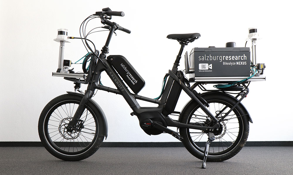
Since 2021, Salzburg Research has used specially designed research bicycles to record and analyze interactions between cyclists and other road users in public traffic environments. The aim is to objectively document real-world traffic situations to enable evidence-based conclusions to be drawn about cyclists’ safety.
A newly developed bicycle, representing a technological advancement over the previous models, has been in use since spring 2026. The Bikealyze NEXUS system architecture includes an embedded high-performance computer, a high-precision GNSS system, two LiDAR sensors (3D laser scanners) for three-dimensional mapping of the surroundings, three cameras and a C-ITS on-board unit. These components enable highly accurate collection of position, motion and environmental data in real-world traffic conditions.
Privacy Notice
The research bicycle is used to capture video footage to investigate safety risks in bicycle traffic and assess the quality of bicycle infrastructure. Data collection has been reported to the Austrian Data Protection Authority.
For further inquiries, please contact: Salzburg Research Forschungsgesellschaft mbH
Cornelia Zankl, cornelia.zankl@salzburgresearch.at, T 0662.2288-317
Three-dimensional representation of the surroundings
The LiDAR data produces point clouds, which are three-dimensional images of the environment. These point clouds can be used to determine the position and size of vehicles, as well as calculate relevant parameters such as distance and speed. This data provides a solid foundation for scientific analysis and developing targeted measures to improve road safety for cyclists.

A wide range of applications for greater road safety
The Holoscene Bike is being used in various research projects aimed at increasing the safety of cyclists on the road. Two key use cases demonstrate this technology’s potential:
Networking with automated vehicles
In the initial application, the Holoscene Bike was equipped with ITS communication technologies that transmitted its position and direction of movement to surrounding vehicles and the traffic infrastructure in real time via a special radio standard. This allowed automated vehicles to detect the bicycle early on, even when it was outside the range of their sensors. At the same time, cyclists received warning messages when potential collisions were detected. This solution was developed and tested as part of the Bike2CAV project, which aims to avoid collisions with cyclists through vehicle-to-X communication.
Measurement of overtaking maneuvers for objective assessment of bicycle traffic safety
Another key application is analyzing overtaking maneuvers between motor vehicles and cyclists, especially in confined road conditions. Salzburg Research has developed a method that uses the Holoscene Bike to systematically record and evaluate these maneuvers. This method uses point clouds generated by LiDAR sensors to identify vehicles and precisely measure their distance from the bicycle during these maneuvers. Analyzing overtaking distances provides important insights into cyclists’ objective safety and supports developing targeted measures to improve cycling infrastructure. This method was used in the following research projects:
- RADBEST – Cycling guidance in confined road conditions
- MZSFreiland – Optimization of cycling infrastructure: Study on multi-purpose lanes with a narrow core lane on Austria’s open roads
The new research bike (starting in 2026) was developed jointly by Salzburg Research and ALP.Lab and built on a compact cargo bike from Kalkhoff.