-
 Manfred Bortenschlager, Elisabeth Häusler, Wolfgang Schwaiger, Roman Egger und Mario Joos (2010):
Evaluation of the Concept of Early Acceptance Tests for Touristic Mobile Applications.
In: Gretzel, U., Law, R., Fuchs, M. (eds.). Information and Communication Technologies in Tourism 2010. Wien, New York: Springer Computer Science.
Manfred Bortenschlager, Elisabeth Häusler, Wolfgang Schwaiger, Roman Egger und Mario Joos (2010):
Evaluation of the Concept of Early Acceptance Tests for Touristic Mobile Applications.
In: Gretzel, U., Law, R., Fuchs, M. (eds.). Information and Communication Technologies in Tourism 2010. Wien, New York: Springer Computer Science.
-
Manfred Bortenschlager, Francesco Manti, Massimo Mecella (2010):
WORKPAD: Task-based and Geo-based Management of Emergency Situations.
In: Proceedings of Geomatics for Crisis Management (Gi4DM), Torino, Italy, 2010.
-
Günter Kiechle (2009):
Solution Procedures for Real-World Vehicle Routing Problems in Health Care.
Dissertation, Universität Wien, 2009.
-
Manfred Bortenschlager (2009):
Location-oriented Coordination in Pervasive Environments for Collaborative Work Scenarios.
In: Journal of Location Based Services, Eds. J. Raper and G. Gartner. 3(4), 229-248.
-
Manfred Bortenschlager (2009):
CorA: Eine Koordinationsarchitektur fur Kollaboration unter mobilen Benutzern.
In: Ausgezeichnete Informatikdissertationen 2008. GI-Edition-Lecture Notes in Informatics (LNI Vol. D-9), Eds. Dorothea Wagner et al., 2009.
-
Manfred Bortenschlager, Nicolas Göll (2009):
Location-based Services: Finally Delivering the Promise?
In: mobile zeitgeist. Das eMag zum Mobilen Business. Ausgabe 04, Oktober 2009.
-
Senthanal Sirpi Manohar, Günter Kiechle (2009):
Performance evaluation of dijkstra’s fastest path algorithm on realistic large street network with dynamic travel times.
Vortrag auf der 23rd European Conference on Operational Research, Bonn.
-
Fritz Payr, Verena Schmid (2009):
Optimizing Deliveries of Ready-Mixed Concrete.
In: Witold Jacak, Michael Affenzeller, Stephan Dreiseitl, Monika Kofler, Thomas Kern (Eds): LINDI 2009 Proceedings (2009 2nd International Symposium on Logistics and Industiral Informatics).
-
Karl Rehrl, Sven Leitinger, Georg Gartner, Felix Ortag (2009):
An analysis of direction and motion concepts in verbal descriptions of route choices.
In: K. Stewart Hornsby et al. (Eds.): COSIT 2009, LNCS 5756, pp. 471-488, Springer-Verlag, Berlin-Heidelberg.
-
Karl Rehrl, Felix Ortag (2009):
An Affordance-based Taxonomy for classifying Landmarks in Route Directions.
In: Electronic Proceedings of the 6th International Symposium on Location Based Services & TeleCartography, Nottingham, UK, 2009, S. 16.
-
Sven Leitinger, Andreas Wagner (2009):
Vulgo-DB: Applikation zur Lokalisierung von Notrufen aus alpinen Umgebungen.
Applikation zur Lokalisierung von Notrufen aus alpinen Umgebungen.
In: J. Strobl (Hrsg.): Angewandte Geoinformatik 2009, Wichmann Verlag Heidelberg.
-
Günter Kiechle, Horst Stadler (2009):
Konzeption einer Servicearchitektur für die Nutzung von Echtzeit-Verkehrsinformationen zur dynamischen Flottendisposition.
In: Geoinformatik 2009, Osnabrück.
-
Günter Kiechle, Senthanal Sirpi Manohar (2009):
Nutzung von Echtzeit-Verkehrsdaten für die Flottensteuerung.
In: Angewandte Geoinformatik 2009, Salzburg.
-
Sven Leitinger, Günter Kiechle (2009):
Entwicklung und Test eines ortsbasierten Notrufsystems für Smartphones in alpiner Umgebung.
In: W. Reinhardt et al. (Eds.): Geoinformatik 2009 - Konferenzband, ifgiprints 35, Münster, Germany.
-
Michael Schilde, Karl Dörner, Richard Hartl, Günter Kiechle (2009):
Metaheuristics for the bi-objective Orienteering Problem.
In: Swarm Intelligence. Vol.3, pp. 179-201
-
Manfred Bortenschlager, Renate Steinmann, et. al. (2009):
Designing Mobile Systems in Highly Dynamic Scenarios.
The WORKPAD Methodology.
In: Journal on Knowledge, Technology, and Policy. 22(1), Springer, 2009
-
Manfred Bortenschlager, Renate Steinmann, et. al. (2009):
The WORKPAD User Interface and Methodology:
Developing Smart and Effective Mobile Applications for Emergency Operators.
In: Proceedings of the HCI International 2009. San Diego, CA, USA, 2009
-
Manfred Bortenschlager, Elisabeth Haid, Andreas Wagner (2009):
Rapid Prototyping of Sensor-Based Applications with SunSPOTs.
In: ERCIM News No. 76, Special theme: The Sensor Web. January 2009
-
Günter Kiechle, Karl Dörner, Stefan Biffl (2009):
Strategies to support ambulance scheduling with efficient routing services.
In: Proceedings of the 9th International Conference on Business Informatics. Vienna, Austria
-
Günter Kiechle, Karl Doerner, Michel Gendreau, Richard Hartl (2009):
Waiting strategies for regular and emergency patient transportation.
In: Proceedings of the OR 2008 Conference, Augsburg, Germany
-
Karl Rehrl, Sven Leitinger (2008):
The SemWay Skitouring Experiment:
How Ski Tourers Find Their Way.
In: Electronic Proceedings of the 5th Symposium on Location Based Services & Telecartography, Salzburg.
-
Sven Leitinger, Bernhard Lorenz, Günther Kiechle (2008):
GPS-Notruf – Prototyp eines ortsbasierten Notrufsystems von GPS-Smartphones.
In: Proceedings AHORN 2008, Salzburg.
-
Manfred Bortenschlager, Nic Goell, Lisi Haid, Massimiliano de Leoni, Massimo Mecella, Harald Rieser, Renate Steinmann. (2008):
Mobile Collaboration Through Context-sensitive Process Management and a Map-based Application.
In: 5th International Symposium on LBS & TeleCartography 2008, Salzburg, Austria
-
Manfred Bortenschlager, Lisi Haid, Michael Hufnagl, Andreas Wagner (2008):
SensorNets@Home.
Indoor Environment Quality with SunSPOT Sensor Technology
In: 5th International Symposium on LBS & TeleCartography 2008, Salzburg, Austria
-
Günter Kiechle, Karl Dörner (2008):
A decision support system for ambulance scheduling.
In: Proceedings of the FH Science Day 2008, Linz, Austria
-
Georg Gartner, Sven Leitinger, Karl Rehrl (2008):
Electronic Proceedings:
Keynotes - Extended Abstracts - LBS Showcases of the 5th Symposium on Location Based Services & Telecartography, Salzburg.
-
Manfred Bortenschlager, et al. (2008):
Coordination of Knowledge in Pervasive Environments.
In: The 17th IEEE International Workshops on Enabling Technologies: Infrastructure for Collaborative Enterprises (WETICE): Coordination Models and Applications (CoMA): Knowledge in Pervasive Environments 2008, Rome, Italy
-
Manfred Bortenschlager, Nic Goell, Elisabeth Haid, Harald Rieser, Renate Steinmann (2008):
GeoCollaboration — Location-based Collaboration in Emergency Scenarios.
In: The 17th IEEE International Workshops on Enabling Technologies: Infrastructure for Collaborative Enterprises (WETICE) 2008, Rome, Italy
-
Georg Gartner, Karl Rehrl (Eds.) (2008):
Location Based Services and TeleCartography II
From Sensor Fusion to Context Models. Springer Verlag.
-
Karl Rehrl, et al. (2008):
Instrumente für ein effektives Verkehrsmanagement bei Großveranstaltungen
In: Strobl, J. et al (Hrsg.): Angewandte Geoinformatik 2008: Beiträge zum 20. AGIT Symposium Salzburg. Wichmann Verlag, Heidelberg, S. 299-304
-
Christian Mueller, Alexander Almer, Harald Stelzl, Manfred Bortenschlager, Markus Lassnig (2008):
Geodatenvisualisierung auf mobilen Geräten.
In: Conference and Exhibition on Applied Geoinformatics (AGIT) 2008, Salzburg
-
Manfred Bortenschlager, Harald Rieser, Berardino Salvatore, Renate Steinmann, Josef Strobl, Guido Vetere (2008):
Integration for Emergency Management Systems
In: GI-Forum at the Conference and Exhibition on Applied Geoinformatics (AGIT) 2008, Salzburg
-
Günter Kiechle, Karl Dörner, Andreas Wagner (2008):
Entwicklung eines Planungswerkzeuges für die Tourenplanung für Außendienstmitarbeiter.
In: Strobl, J., Blaschke, T., Griesebner, G. (Hg.): Angewandte Geoinformatik 2008, 2.-4. Juli 2008, Herbert Wichmann Verlag, Heidelberg, S. 418-423
-
Manfred Bortenschlager, Gabriele Kotsis, Marco Mamei (eds.) (2008):
Special Issue on Coordination in Pervasive Environments.
In: Ubiquitous Computing and Communication Journal UBICC: 3, 2008
-
Manfred Bortenschlager, Gabriele Kotsis, Marco Mamei (2008):
Towards a Coordination Framework for Pervasive Environments.
In: UBICC SI on Coordination in Pervasive Environments. Ubiquitous Computing and Communication Journal UBICC: 3, 2008
-
Andrea Marrella, Ruggero Russo, Andrea Capata, Manfred Bortenschlager, Harald Rieser (2008):
A Geo-based Application for the Management of Mobile Agents during Crisis Situations.
In: Proceedings of the 5th International ISCRAM Conference, Washington, DC, USA, 2008
-
Elisabeth Haid, Günter Kiechle, Nicolas Göll, Martin Soutschek (2008):
Evaluation of a Web-based and Mobile Ski Touring Application for GPS-enabled Smartphones.
In: Sigala, M., Mich, L., Murphy, J. (eds.). Information and Communication Technologies in Tourism 2007. Wien, New York: Springer Computer Science.
-
Günter Kiechle, Karl Dörner, Michel Gendreau, Richard Hartl (2007):
Patient Transportation – Dynamic Dial-a-Ride and Emergency Transportation Problems.
In: Preprints of Triennial Symposium on Transportation Analysis (TRISTAN) 2007
-
Karl Dörner, Manfred Gronalt, Richard Hartl, Günter Kiechle, Marc Reimann (2007):
Exact and Heuristic Algorithms for the Vehicle Routing Problem with Multiple, Interdependent Time Windows.
In: Computers & Operations Research (accepted for publication)
-
Günter Kiechle, Nicolas Göll (2007):
TourGuide – ein Informations- und Navigationssystem für Bergwanderer und Skitourengeher.
In: Dreiländertagung: Der Alpenraum und seine Herausforderungen an Orientierung, Navigation und Informationsaustausch (AHORN 2007), Bad Reichenhall, November 2007
-
Karl Rehrl, Sven Leitinger, Georg Gartner (2007):
The SemWay Project – Towards Semantic Navigation Systems
In: Proceedings of the 4th International Symposium on LBS & TeleCartography, Hong Kong, 2007
-
Günter Kiechle, Nicolas Göll, Karl Rehrl (2007):
TourGuide – A Navigation System for Ski Tourers on GPS-enabled Smartphones.
In: Proceedings of the 4th International Symposium on LBS & TeleCartography, Hong Kong, 2007
-
Karl Rehrl, Nicolas Göll, Sven Leitinger, S. Bruntsch, H.-J. Mentz (2007):
Smartphone-based Information and Navigation Aids for Public Transport.
In: G. Gartner et. al. (Eds.), Location Based Services and TeleCartography, Lecture Notes in Geoinformation and Cartography, Springer Verlag
-
Erich Gams, Karl Rehrl, Daniel Kaschl (2007):
Using other People’s Trails for Navigation Assistance
In: Proceedings of the 5th Geographic Information Days, 10.-12. September 2007, Münster, Germany
-
Günter Kiechle, Karl Dörner (2007):
Ein Pilotsystem zur Planung effizienter Touren für den Transport von Blutspenden
In: In: Strobl, J., Blaschke, T., Griesebner, G. (Hg.): Angewandte Geoinformatik 2007, 4.-6. Juli 2007, Herbert Wichmann Verlag, Heidelberg
-
Manfred Bortenschlager, Karl Rehrl (2007):
BlueVote – A Ubiquitous Audience Voting Service
In: Adjunct Proceedings of the 9th International Conference on Ubiquitous Computing UbiComp
-
Manfred Bortenschlager, Sven Leitinger, Harald Rieser, Renate Steinmann (2007):
Towards a P2P-based GeoCollaboration System for Disaster Management
In: GI-Days 2007, Münster, Germany
-
Manfred Bortenschlager, Thomas Fichtel, Sven Leitinger, Harald Rieser, Renate Steinmann (2007):
A Map- and Location-based GeoCollaboration System for Disaster Management in Outdoor Environments
In: 4th International Symposium on LBS & TeleCartography 2007, Hong Kong
-
Manfred Bortenschlager, Gabriele Kotsis, Marco Mamei (2007):
Current Developments and Future Challenges of Coordination in Pervasive Environments
In: The 16th IEEE International Workshops on Enabling Technologies: Infrastructure for Collaborative Enterprises (WETICE): Workshop on Interdisciplinary Aspects of Coordination Applied to Pervasive Environments: Models and Applications (CoMA) 2007, Paris
-
Günter Kiechle (2007):
Entwicklung eines Metasuchverfahrens für die individuelle Planung von Touren für Freizeitaktivitäten
In: In: Strobl, J., Blaschke, T., Griesebner, G. (Hg.): Angewandte Geoinformatik 2007, 4.-6. Juli 2007, Herbert Wichmann Verlag, Heidelberg
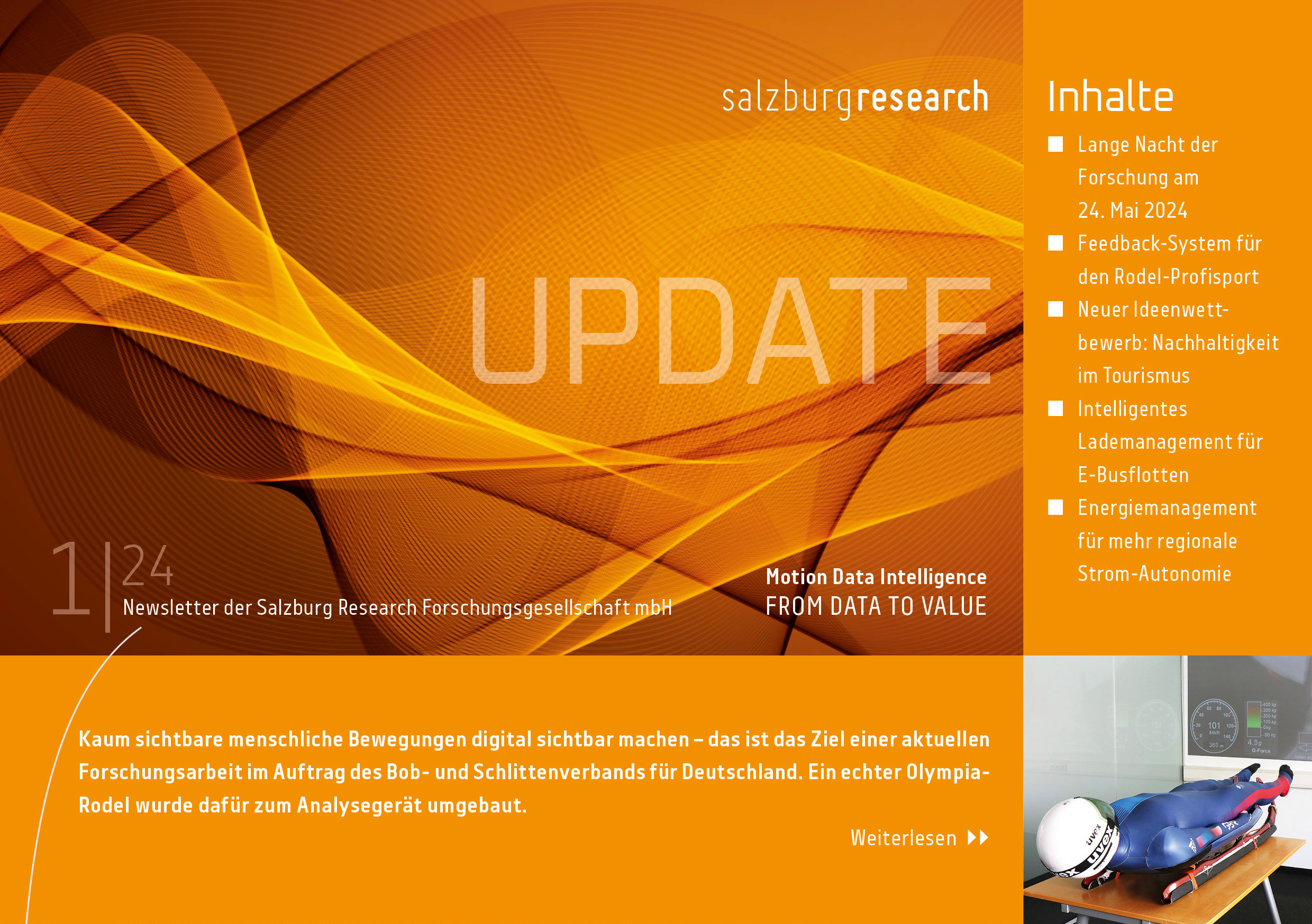
Newsletter
Erhalten Sie viermal jährlich unseren postalischen Newsletter sowie Einladungen zu Veranstaltungen. Kostenlos abonnieren.
Kontakt
Salzburg Research Forschungsgesellschaft
Jakob Haringer Straße 5/3
5020 Salzburg, Austria
Jakob Haringer Straße 5/3
5020 Salzburg, Austria
Aktuelle Unternehmenspublikationen

 © 2024 Salzburg Research Zertifiziert nach EN ISO 9001